
Climate-adaptive Design Studio (CaD)
In the fall semester of 2022, the Village of Tarrytown was fortunate to work in collaboration with Cornell University's Department of Landscape Architecture and the New York Department of Environmental Conservation Hudson Estuary Program to examine the Village waterfront through the lens of the Climate-Adaptive Design (CaD) Studio.
The Climate-adaptive Design (CaD) Studio is a semester-long course created by Cornell Department of Landscape Architecture Associate Professor Joshua F. Cerra that links students with Hudson riverfront communities to explore design alternatives for more climate resilient and connected waterfront areas. The CaD studio assists municipalities in evaluating their waterfront and developing a vision for integration of diverse uses in ways that are visually appealing, highly functional, and resilient to flooding and other climate-related risks. The studio highlights the choices faced by communities impacted by sea-level rise, which is projected to continue through the end of the century and beyond. The CaD studio emphasizes design principles that embrace water-dependent and water-enhanced uses, utilize nature-based solutions, and anticipate changing conditions over time.
CaD in Tarrytown
The CaD studio process began with a site analysis to better understand the host community. The students visited Tarrytown on September 9, 2022, and met with community stakeholders to learn about concerns and vision for the future waterfront. Student designers study land use, planning, zoning, local history, ecosystems, flooding and sea-level rise projections for the study area. They then meet with community members to develop insights into the needs and interests of the municipality. The students returned on October 19, 2022 to present preliminary designs, seeking feedback from community members. Students then refined their design concepts based on the information and feedback gathered, and sought to incorporate diverse perspectives into a cross section of design ideas ranging from the practical to the visionary.
The Village of Tarrytown hosted its final event of the Climate Adaptive Design Studio on December 12, 2022 at the Tarrytown Senior Center. The 14 student groups from the Cornell University Landscape Architecture Department presented their final designs. The event was translated into Spanish, and a video of the presentation and student designs can be found below.
Final Project Resources
CaD Story Map: a succinct visual explanation of the Project findings: https://storymaps.arcgis.com/stories/4f7ee7ced8814f3d8c1ff304bd3e5c57
Final Look Book: A Graphic Summary of the Project findings
Climate-adaptive Design Studio Final Poster Panels: Posters will be displayed in Warner Library
Climate-adaptive Design Studio Final Poster Panels IN SPANISH
Next Steps
1) The Village will be hosting community information sessions about the final CaD Project findings at the TEAC Eco-Fair in Patriots Park on October 14.
2) The Village would like to pursue opportunities through CaD Phase II, a program through the DEC Hudson Estuary Program that builds off of the CaD Phase I learning in collaboration with a professional design team and extensive community engagement, to come up with an actionable plan to develop a resilient waterfront. the DEC Estuary Program provides funding for the work.
Examples of CaD Phase II plans from other Hudson River communities: Kingston, Hudson
Additional Resources and information related to the project:
Fact Sheet about the CaD Studio
Fact Sheet in Spanish about the CaD Studio
Presentation Slides from Dec 12 Open House
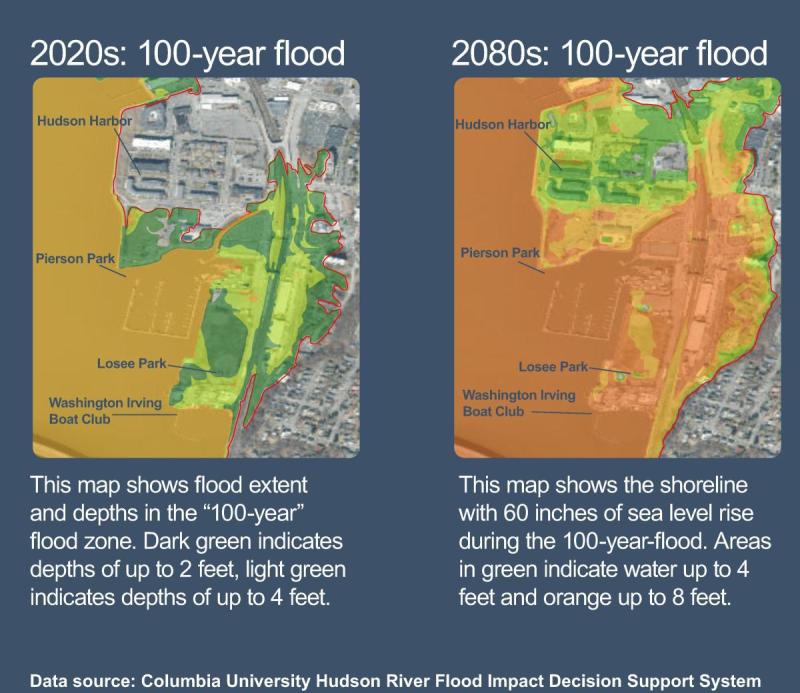
These are the presentation slides from the September 9th meetings that include information about flood projections through 2080 and potential estimated costs for the Village associated with future storm damage.
This summary of the meeting discussions reflects both concerns about and visions for the Village waterfront from community members.
This free online mapping tool sponsored by Scenic Hudson allows you to see impacts on our shoreline for different ranges of projected sea level rise.
Some of the other tools used by the DEC and Cornell to estimate costs and impact of seal level rise:
The student work is based on NYS sea-level rise projections. You can check out the NYS DEC sea-level rise projections here: https://www.dec.ny.gov/regulations/103877.html
The Columbia University Hudson River Decision Support System Tool: http://www.ciesin.columbia.edu/hudson-river-flood-map/
Sea Level Affecting Marshes Modeling Tool (SLAMM): https://longislandsoundstudy.net/research-monitoring/slamm/
The above resources are models so they are not precise, but can help us estimate what may be possible in the future.
NYS provides guidance on coastal development through their Model Local Laws to Increase Resilience resource, which can be accessed here: https://dos.ny.gov/model-local-laws-increase-resilience
| Attachment | Size |
|---|---|
| 4.2 MB | |
| 61.75 KB | |
| 1.57 MB | |
| 6.9 MB | |
| 2.78 MB | |
| 34.98 MB | |
| 35.01 MB |